
Summary Preparing for Wildfire and Taking Action from Palo Alto CERT Trainers on Actions and Resource for WIldfires
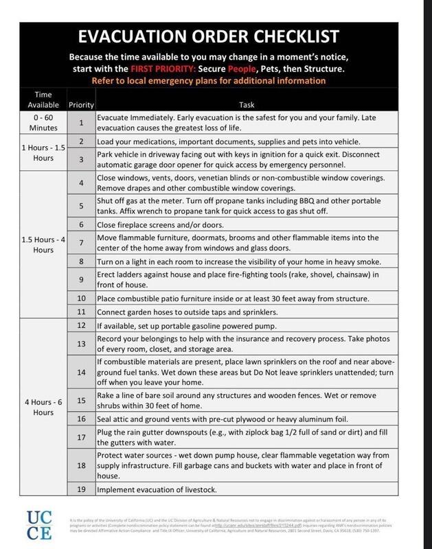
Special notes for California Wildfires in August 2020Contributed by Palo Alto CERT trainers David Rost & John Mori INTRODUCTION: Below are some tips for people living in a possible evacuation zone for fire, hurricane, or other event. These notes are specific to the fires we are currently (August 2020) experiencing in California. There are a fraction of normal resources normally assigned to incidents of this size. They don’t have enough equipment or people to rescue anyone who stays behind and it puts responders at a high level of risk if they were to try. Responders need rapid access; people clogging roads slows deployment of equipment and resources. Responders need to quickly hop-scotch as the fire changes direction and moves through neighborhoods given how erratic things can unfold with wind, spotting, etc. • Trust responder experience and instincts when they say evacuate. • If they say leave get out and do not linger to see what happens. • These fires are moving much faster than you think. . GETTING READY: Be ready to leave at a moments notice . If you are on evacuation watch, make sure at least one person in the house is paying attention to current conditions. Don’t wake up with fire on your front door! CARS: Keep your gas tanks full! Your escape is completely dependent on your vehicles.
HOME (if you are on evacuation alert)[1]
KNOW YOUR EXIT ROUTES: If you live where there could be the possibility of future evacuation, figure out two exit routes beforehand.
LODGING: These fires are so big and so many are being displaced/evacuated that getting a hotel room is very difficult if not impossible.
PACK AN OVERNIGHT BAG: Pack a bag with cloths and toiletries for a several of days. If you have pets account for what they need too
PAPERS/PHOTOS: Figure out what papers and photos you would take in advance. You can use blue painter tape to mark things you want to take. Hard to keep your mind on task at a high stress level with a short time to act.
PROOF FOR INSURANCE: Video everything in your house and garage so you have a record for insurance and you remember to capture everything. This is invaluable if you ever need to make a claim. . TIMING: We hope there is a break in the weather so responders can gain some containment. Given the long range forecast and number/size of these fires this is going to be a long term event.
IF YOU GET CAUGHT IN A WILDFIRE : Best tip is to think ahead about what you would do as you are hiking or are out in the mountains. Be situationally aware about your surroundings – what is your escape route? If a fire starts evacuate/exit the area immediately. Don’t hang around to see what happens. Rate of spread doubles every minute or so; faster with wind, low humidity, and hot ambient air temperature.
SHORT VIDEO TO COVER BASICS https://www.youtube.com/watch?time_continue=1&v=IkAv4tdQyKs&feature=emb_logo TRACKING EVACUATION INFORMATION: Things change so fast it is hard for responders to give warning to evacuate. Responders are so busy dealing with the immediate situation it is hard to even keep the flow of information updated. Below are some possible links for current information. AERIAL COVERAGEhttps://www.nbcbayarea.com/news/local/aerial-coverage-of-lightning-sparked-wildfires-in-thebay-area/2348431/ CalFire Maps/Twitter https://www.fire.ca.gov/incidents/ https://twitter.com/CALFIRECZU https://twitter.com/CALFIRESCU https://twitter.com/CALFIRELNU GOOGLE MAPS https://www.google.com/maps/@38.6127738,-123.2005548,9z/data=!4m3!15m2!1m1! https://www.google.com/maps/@37.2613287,-122.5202435,10z/data=!3m1!4b1!4m3!15m2! https://www.google.com/maps/@37.449557,-121.7942607,10z/data=!3m1!4b1!4m3!15m2!1m1! 1s%2Fg%2F11kn6scznf SCANNER: Load a scanner app on your phone to hear what CalFire is doing. Below is a link to CalFire scanner frequencies if you have a scanner. http://www.scancal.org/calfire/index.html WEBCAMShttp://www.alertwildfire.org/northbay/ https://www.rntl.net/MtDiabloCam.htm https://mthamilton.ucolick.org/hamcam/ https://www.see.cam/us/ca/san-jose/mount-hamilton https://www.windfinder.com/webcams/mt_umunhum TERMS: Below are some terms to understand what is happening with a given wildfire.
https://www.fire.ca.gov/media/4938/fireterminology.pdf https://www.fs.fed.us/nwacfire/home/terminology.html [1] Source: FEMA CERT Supplemental Training information 2011 |
NAVIGATION
WILDFIRE RESOURCES
|